
Thank you for supporting this site ❤️
Make a donation
Make a donation
Santa Coloma topographic map
Click on the map to display elevation.
Thank you for supporting this site ❤️
Make a donation
Make a donation
About this map
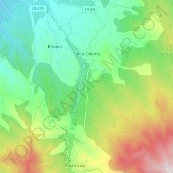
Name: Santa Coloma topographic map, elevation, terrain.
Location: Santa Coloma, La Rioja, Espanha (42.32754 -2.66525 42.38640 -2.60740)
Average elevation: 898 m
Minimum elevation: 589 m
Maximum elevation: 1,489 m
Thank you for supporting this site ❤️
Make a donation
Make a donation
Other topographic maps
Click on a map to view its topography, its elevation and its terrain.