
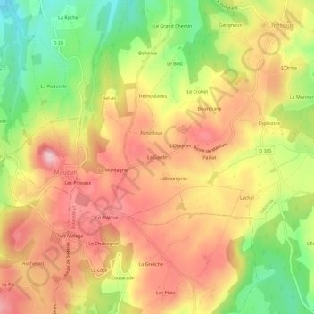
La Garde topographic map
Interactive map
Click on the map to display elevation.
About this map
Name: La Garde topographic map, elevation, terrain.
Average elevation: 546 m
Minimum elevation: 419 m
Maximum elevation: 645 m
Other topographic maps
Click on a map to view its topography, its elevation and its terrain.
Le Bost
France > Auvergne-Rhône-Alpes > Puy-de-Dôme > Trézioux
Le Bost, Trézioux, Clermont-Ferrand, Puy-de-Dôme, Auvergne-Rhône-Alpes, France métropolitaine, 63520, France
Average elevation: 521 m
Lachal
France > Auvergne-Rhône-Alpes > Puy-de-Dôme > Trézioux
Lachal, Trézioux, Clermont-Ferrand, Puy-de-Dôme, Auvergne-Rhône-Alpes, France métropolitaine, 63520, France
Average elevation: 537 m
La Dugne
France > Auvergne-Rhône-Alpes > Puy-de-Dôme > Trézioux > La Dugne
La Dugne, Trézioux, Clermont-Ferrand, Puy-de-Dôme, Auvergne-Rhône-Alpes, France métropolitaine, 63520, France
Average elevation: 502 m