
Thank you for supporting this site ❤️
Make a donation
Make a donation
Lahnbahnhof topographic map
Click on the map to display elevation.
Thank you for supporting this site ❤️
Make a donation
Make a donation
About this map
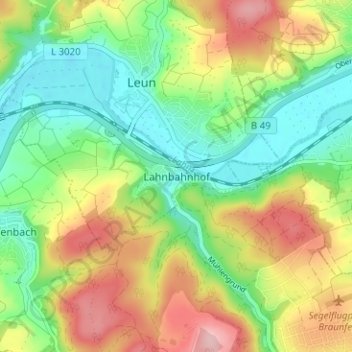
Name: Lahnbahnhof topographic map, elevation, terrain.
Location: Lahnbahnhof, Leun, Lahn-Dill-Kreis, Hessen, 35638, Deutschland (50.51950 8.34355 50.55950 8.38355)
Average elevation: 202 m
Minimum elevation: 134 m
Maximum elevation: 300 m
Thank you for supporting this site ❤️
Make a donation
Make a donation
Other topographic maps
Click on a map to view its topography, its elevation and its terrain.