
Thank you for supporting this site ❤️
Make a donation
Make a donation
Fördergersdorf topographic map
Click on the map to display elevation.
Thank you for supporting this site ❤️
Make a donation
Make a donation
About this map
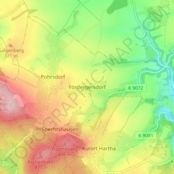
Name: Fördergersdorf topographic map, elevation, terrain.
Average elevation: 335 m
Minimum elevation: 242 m
Maximum elevation: 435 m
Thank you for supporting this site ❤️
Make a donation
Make a donation
Other topographic maps
Click on a map to view its topography, its elevation and its terrain.
Schutzhütte der Sektion Wandern und Bergsteigen
Deutschland > Sachsen > Sächsische Schweiz-Osterzgebirge > Tharandt
Average elevation: 312 m