
Drang Drung Glacier topographic map
Interactive map
Click on the map to display elevation.
Drang Drung Glacier
The Drang-Drung Glacier is likely to be the largest glacier in Ladakh after the Siachen Glacier in the Karakoram Range, with a maximum length of 23 km (14 mi) at an average elevation of 4,780 m (15,680 ft; 2.97 mi). The glacier lies in the northeastern Himalayan Range known as the Zanskar Range, 142 km (88 mi) south of Kargil and 331 km (206 mi) east of Srinagar, the capital of Jammu and Kashmir.
About this map
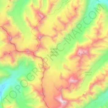
Name: Drang Drung Glacier topographic map, elevation, terrain.
Average elevation: 5,098 m
Minimum elevation: 3,938 m
Maximum elevation: 6,533 m
Other topographic maps
Click on a map to view its topography, its elevation and its terrain.