
Rhens topographic map
Interactive map
Click on the map to display elevation.
About this map
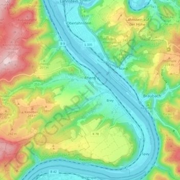
Name: Rhens topographic map, elevation, terrain.
Average elevation: 181 m
Minimum elevation: 62 m
Maximum elevation: 398 m
Other topographic maps
Click on a map to view its topography, its elevation and its terrain.
Gering
Germany > Rhineland-Palatinate > Landkreis Mayen-Koblenz
Gering, Maifeld, Landkreis Mayen-Koblenz, Rhineland-Palatinate, Germany
Average elevation: 313 m
Polch
Germany > Rhineland-Palatinate > Landkreis Mayen-Koblenz
Polch, Maifeld, Landkreis Mayen-Koblenz, Rhineland-Palatinate, 56751, Germany
Average elevation: 235 m
Mendig
Germany > Rhineland-Palatinate > Landkreis Mayen-Koblenz
Mendig, Landkreis Mayen-Koblenz, Rhineland-Palatinate, 56743, Germany
Average elevation: 265 m