
Wernigerode topographic map
Interactive map
Click on the map to display elevation.
About this map
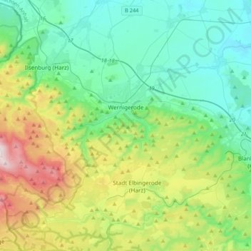
Name: Wernigerode topographic map, elevation, terrain.
Location: Wernigerode, Landkreis Harz, Saxony-Anhalt, Germany (51.75220 10.57385 51.88704 10.90049)
Average elevation: 381 m
Minimum elevation: 139 m
Maximum elevation: 1,062 m
Other topographic maps
Click on a map to view its topography, its elevation and its terrain.
Schierke
Germany > Saxony-Anhalt > Landkreis Harz > Wernigerode
Schierke, Wernigerode, Landkreis Harz, Saxony-Anhalt, 38879, Germany
Average elevation: 707 m
Hasselfelde
Germany > Saxony-Anhalt > Landkreis Harz
Hasselfelde, Oberharz am Brocken, Landkreis Harz, Saxony-Anhalt, 38899, Germany
Average elevation: 494 m
Thale
Germany > Saxony-Anhalt > Landkreis Harz > Thale
Thale, Landkreis Harz, Saxony-Anhalt, 06502, Germany
Average elevation: 304 m
Brocken
Germany > Saxony-Anhalt > Landkreis Harz > Wernigerode
Brocken, Wernigerode, Landkreis Harz, Saxony-Anhalt, Germany
Average elevation: 963 m