
Thank you for supporting this site ❤️
Make a donation
Make a donation
Hagarville topographic map
Click on the map to display elevation.
Thank you for supporting this site ❤️
Make a donation
Make a donation
About this map
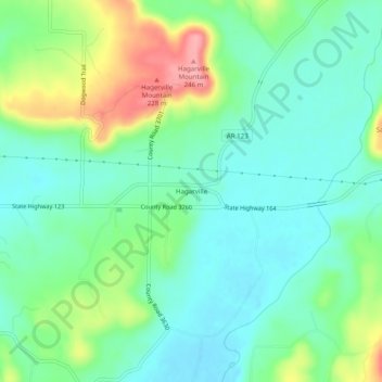
Name: Hagarville topographic map, elevation, terrain.
Location: Hagarville, Johnson County, Arkansas, United States (35.49564 -93.34490 35.53564 -93.30490)
Average elevation: 173 m
Minimum elevation: 140 m
Maximum elevation: 247 m
Thank you for supporting this site ❤️
Make a donation
Make a donation
Other topographic maps
Click on a map to view its topography, its elevation and its terrain.
Clarksville
United States > Arkansas > Johnson County
Spadra was the first county seat of Johnson County, convenient to steamboat lines. However, when stagecoach and train transportation became more common, land routes from Little Rock to Fort Smith were directed along higher elevations through Clarksville. As Clarksville grew, it became the de facto location for…
Average elevation: 137 m