
Förolach topographic map
Interactive map
Click on the map to display elevation.
About this map
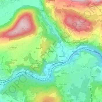
Name: Förolach topographic map, elevation, terrain.
Average elevation: 655 m
Minimum elevation: 510 m
Maximum elevation: 886 m
Other topographic maps
Click on a map to view its topography, its elevation and its terrain.
Rabensdorf
Oostenrijk > Karinthië > Feldkirchen in Kärnten > Sonnrain > Rabensdorf
Rabensdorf, Sonnrain, Feldkirchen in Kärnten, Bezirk Feldkirchen, Karinthië, 9560, Oostenrijk
Average elevation: 591 m