
Bad Godesberg topographic map
Interactive map
Click on the map to display elevation.
About this map
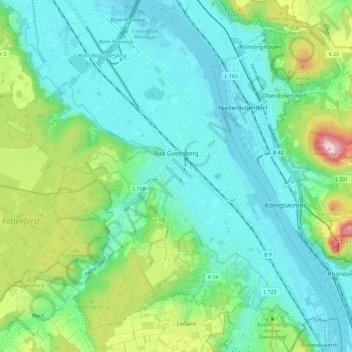
Name: Bad Godesberg topographic map, elevation, terrain.
Location: Bad Godesberg, Bonn, Nordrhein-Westfalen, Deutschland (50.64249 7.10536 50.71772 7.21068)
Average elevation: 118 m
Minimum elevation: 48 m
Maximum elevation: 335 m
Die Zentrale des Nationalen Cyber-Abwehrzentrums befindet sich im Stadtbezirk Bad Godesberg. Auf der Viktorshöhe im Ortsteil Schweinheim ist seit 1999 ein Generalkonsulat der Russischen Föderation in den Gebäuden der vormaligen Botschaft ansässig. In Bad Godesberg sind darüber hinaus heute noch Außenstellen der Botschaft der Volksrepublik China, der Libyschen Botschaft, der südkoreanischen Botschaft, der Botschaft der Republik Kuba und der Botschaft von Kirgisistan beheimatet.
Other topographic maps
Click on a map to view its topography, its elevation and its terrain.
Ramersdorf
Deutschland > Nordrhein-Westfalen > Bonn
Ramersdorf, Bonn-Beuel, Bonn, Nordrhein-Westfalen, 53227, Deutschland
Average elevation: 87 m
Bonn
Deutschland > Nordrhein-Westfalen > Bonn
Bonn, Regierungsbezirk Köln, Nordrhein-Westfalen, 53111, Deutschland
Average elevation: 138 m
Hardthöhe
Deutschland > Nordrhein-Westfalen > Bonn
Hardthöhe, Hardtberg, Bonn, Regierungsbezirk Köln, Nordrhein-Westfalen, Deutschland
Average elevation: 141 m