
Thank you for supporting this site ❤️
Make a donation
Make a donation
Fergana Region topographic map
Click on the map to display elevation.
Thank you for supporting this site ❤️
Make a donation
Make a donation
About this map
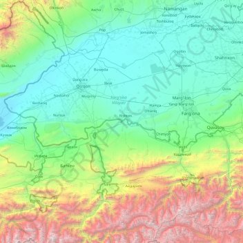
Name: Fergana Region topographic map, elevation, terrain.
Location: Fergana Region, Uzbekistan (39.89837 70.32817 40.77272 72.23670)
Average elevation: 1,355 m
Minimum elevation: 345 m
Maximum elevation: 5,369 m
Thank you for supporting this site ❤️
Make a donation
Make a donation
Other topographic maps
Click on a map to view its topography, its elevation and its terrain.
Thank you for supporting this site ❤️
Make a donation
Make a donation
Thank you for supporting this site ❤️
Make a donation
Make a donation
Jizzax
From the slopes of the mountains at an altitude of 1800 meters above sea level, pine forests begin. As the mountains rise, the pine forest thickens.
Average elevation: 381 m
Thank you for supporting this site ❤️
Make a donation
Make a donation