
Make a donation
Beli Potok topographic map
Click on the map to display elevation.
Make a donation
About this map
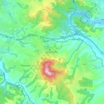
Name: Beli Potok topographic map, elevation, terrain.
Location: Beli Potok, City of Belgrade, Central Serbia, 11223, Serbia (44.66551 20.47896 44.74551 20.55896)
Average elevation: 201 m
Minimum elevation: 91 m
Maximum elevation: 500 m
Make a donation
Other topographic maps
Click on a map to view its topography, its elevation and its terrain.
Mladenovac Urban Municipality
Serbia > Central Serbia > City of Belgrade
Kosmaj with its altitude of 628 m is the highest point in this region. A monument dedicated to Serbs (Partisans) who lost their lives in World War II fights that took place in this area sits at the top of this mountain.
Average elevation: 211 m
Make a donation
Zemun
Serbia > Central Serbia > City of Belgrade > Belgrade
One of the characteristics of the Zemun's topography are the lagums, artificial underground corridors which crisscross below the loess area of Gardoš, Muhar, Ćukovac and Kalvarija. This terrain is one of the most active landslide areas in Belgrade. Being cut into for centuries, the loess in some sections…
Average elevation: 80 m
Make a donation