
es Gentils topographic map
Interactive map
Click on the map to display elevation.
About this map
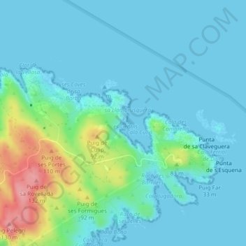
Name: es Gentils topographic map, elevation, terrain.
Average elevation: 23 m
Minimum elevation: 0 m
Maximum elevation: 124 m
Other topographic maps
Click on a map to view its topography, its elevation and its terrain.
Platja Gran
Espagne > Catalogne > Cadaqués > Port Lligat
Platja Gran, Avinguda de Caritat Serinyana, Port Lligat, Cadaqués, Haut-Ampurdan, Gérone, Catalogne, 17488, Espagne
Average elevation: 52 m