
Thank you for supporting this site ❤️
Make a donation
Make a donation
Dellmensingen topographic map
Click on the map to display elevation.
Thank you for supporting this site ❤️
Make a donation
Make a donation
About this map
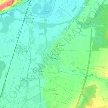
Name: Dellmensingen topographic map, elevation, terrain.
Average elevation: 490 m
Minimum elevation: 472 m
Maximum elevation: 536 m
Thank you for supporting this site ❤️
Make a donation
Make a donation
Other topographic maps
Click on a map to view its topography, its elevation and its terrain.
89155
Deutschland > Baden-Württemberg > Alb-Donau-Kreis > Erbach > Donaurieden
Average elevation: 497 m
Thank you for supporting this site ❤️
Make a donation
Make a donation
Steinenfeld
Deutschland > Baden-Württemberg > Alb-Donau-Kreis > Erbach > Steinenfeld
Average elevation: 633 m