
Noordwijk topographic map
Interactive map
Click on the map to display elevation.
About this map
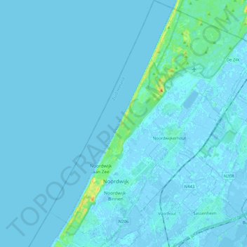
Name: Noordwijk topographic map, elevation, terrain.
Location: Noordwijk, South Holland, Netherlands (52.20736 4.39098 52.33251 4.54337)
Average elevation: 1 m
Minimum elevation: -5 m
Maximum elevation: 27 m
Other topographic maps
Click on a map to view its topography, its elevation and its terrain.
Noordwijkerhout
Netherlands > South Holland > Noordwijk
Noordwijkerhout, Noordwijk, South Holland, Netherlands
Average elevation: 2 m
Ruigenhoek
Netherlands > South Holland > Noordwijk > De Zilk > Ruigenhoek
Ruigenhoek, De Zilk, Noordwijk, South Holland, Netherlands, 2191AH, Netherlands
Average elevation: 2 m
De Zilk
Netherlands > South Holland > Noordwijk
De Zilk, Noordwijk, South Holland, Netherlands
Average elevation: 2 m