
Thank you for supporting this site ❤️
Make a donation
Make a donation
Coxheath topographic map
Click on the map to display elevation.
Thank you for supporting this site ❤️
Make a donation
Make a donation
About this map
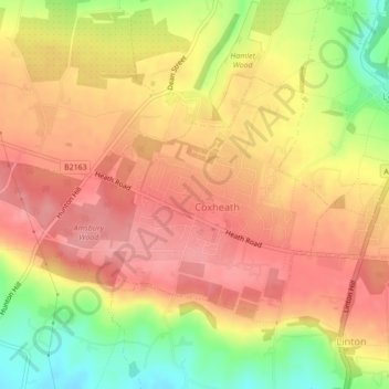
Name: Coxheath topographic map, elevation, terrain.
Location: Coxheath, Maidstone, Kent, England, United Kingdom (51.22614 0.47648 51.24256 0.50943)
Average elevation: 97 m
Minimum elevation: 34 m
Maximum elevation: 134 m
Thank you for supporting this site ❤️
Make a donation
Make a donation
Other topographic maps
Click on a map to view its topography, its elevation and its terrain.
Thank you for supporting this site ❤️
Make a donation
Make a donation
Thank you for supporting this site ❤️
Make a donation
Make a donation
Thank you for supporting this site ❤️
Make a donation
Make a donation
Thank you for supporting this site ❤️
Make a donation
Make a donation
The Hernitage and High Noon Farm
United Kingdom > England > Kent > Maidstone > Detling
Average elevation: 145 m
Thank you for supporting this site ❤️
Make a donation
Make a donation