
Gassen topographic map
Interactive map
Click on the map to display elevation.
About this map
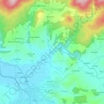
Name: Gassen topographic map, elevation, terrain.
Average elevation: 305 m
Minimum elevation: 232 m
Maximum elevation: 499 m
Other topographic maps
Click on a map to view its topography, its elevation and its terrain.
Schönbuch
Österreich > Niederösterreich > Bezirk Melk > Gemeinde St. Leonhard am Forst > Gassen
Schönbuch, Gassen, Gemeinde St. Leonhard am Forst, Bezirk Melk, Niederösterreich, 3243, Österreich
Average elevation: 304 m