
Frasnes-lez-Anvaing topographic map
Interactive map
Click on the map to display elevation.
About this map
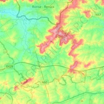
Name: Frasnes-lez-Anvaing topographic map, elevation, terrain.
Location: Frasnes-lez-Anvaing, Ath, Hennegau, Wallonien, Belgien (50.62591 3.48732 50.73473 3.73140)
Average elevation: 56 m
Minimum elevation: 12 m
Maximum elevation: 145 m
Other topographic maps
Click on a map to view its topography, its elevation and its terrain.
Grand Monchau
Belgien > Hennegau > Ath > Ellezelles > Grand Monchau
Grand Monchau, Ellezelles, Ath, Hennegau, Wallonien, 7890, Belgien
Average elevation: 74 m