
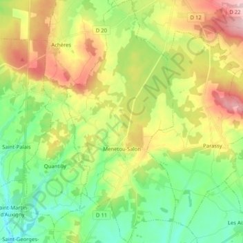
Menetou-Salon topographic map
Interactive map
Click on the map to display elevation.
About this map
Name: Menetou-Salon topographic map, elevation, terrain.
Average elevation: 235 m
Minimum elevation: 154 m
Maximum elevation: 362 m
Menetou-Salon ist eine französische Gemeinde im Département Cher, in der Region Centre-Val de Loire. Die Gemeinde liegt etwa 16 km nördlich von Bourges auf einer Höhe von 210 m. Die 1614 Einwohner (Stand 1. Januar 2020) werden Monestrosaloniens genannt. Menetou-Salon verfügt über eine Fläche von 37,66 km².
Other topographic maps
Click on a map to view its topography, its elevation and its terrain.
Bourges
Frankreich > Zentrum-Loiretal > Cher
Bourges, Cher, Zentrum-Loiretal, Metropolitanes Frankreich, 18000, Frankreich
Average elevation: 146 m
Cogny
Frankreich > Zentrum-Loiretal > Cher > Cogny
Cogny, Saint-Amand-Montrond, Cher, Zentrum-Loiretal, Metropolitanes Frankreich, 18130, Frankreich
Average elevation: 189 m