
Braintree topographic map
Click on the map to display elevation.
About this map
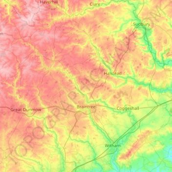
Name: Braintree topographic map, elevation, terrain.
Location: Braintree, Essex, England, United Kingdom (51.75041 0.37961 52.08703 0.78225)
Average elevation: 66 m
Minimum elevation: 3 m
Maximum elevation: 129 m
Other topographic maps
Click on a map to view its topography, its elevation and its terrain.
Hedingham Castle
United Kingdom > England > Essex > Braintree > Castle Hedingham
Average elevation: 67 m
Coles Green
United Kingdom > England > Essex > Uttlesford > Berden > Little London
Average elevation: 100 m
Nazeing Gate
United Kingdom > England > Essex > Epping Forest > Bumble's Green > Nazeing
Average elevation: 70 m
Roughtalley's Wood (South) & Epping Forest Woodland Burial Ground
United Kingdom > England > Essex > Epping Forest > Coopersale
Average elevation: 96 m
Watch House Green
United Kingdom > England > Essex > Uttlesford > Felsted > Watch House Green
Average elevation: 69 m
Wivenhoe Woods
United Kingdom > England > Essex > Colchester > Wivenhoe > Rowhedge
Average elevation: 18 m
M25 Pollution Control Device
United Kingdom > England > Essex > South Ockendon
Average elevation: 19 m