
Huánuco topographic map
Interactive map
Click on the map to display elevation.
About this map
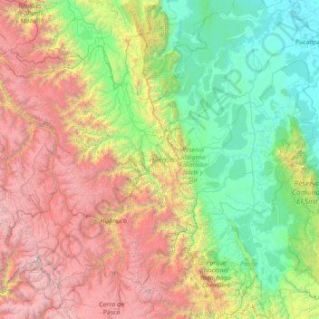
Name: Huánuco topographic map, elevation, terrain.
Location: Huánuco, Peru (-10.48889 -77.31749 -8.31433 -74.52535)
Average elevation: 1,829 m
Minimum elevation: 135 m
Maximum elevation: 6,273 m
Huánuco has a mild semi-arid climate. The temperatures are pleasant (with warm days and cool nights) throughout the year due to its elevation (1913 mt. - 6275 feet).
Other topographic maps
Click on a map to view its topography, its elevation and its terrain.
Province of Puerto Inca
Peru > Huánuco > Puerto Inca
Province of Puerto Inca, Puerto Inca, Huánuco, Peru
Average elevation: 234 m