
Gemeinde Elbigenalp topographic map
Interactive map
Click on the map to display elevation.
About this map
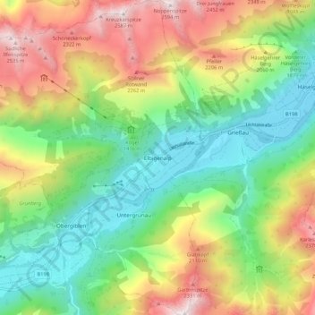
Name: Gemeinde Elbigenalp topographic map, elevation, terrain.
Location: Gemeinde Elbigenalp, Bezirk Reutte, Tirol, 6652, Österreich (47.25528 10.35362 47.32692 10.45289)
Average elevation: 1,667 m
Minimum elevation: 1,018 m
Maximum elevation: 2,589 m
Elbigenalp (Lechtalerisch auch „Duarf“ genannt) ist eine Gemeinde des Bezirks Reutte in Tirol (Österreich) mit 884 Einwohnern (Stand 1. Jänner 2021). Sie ist 33,09 km² groß und befindet sich auf 1039 m Seehöhe. Die Gemeinde liegt im Gerichtsbezirk Reutte.