
Perugia topographic map
Interactive map
Click on the map to display elevation.
About this map
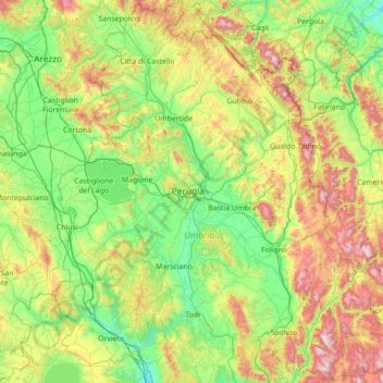
Name: Perugia topographic map, elevation, terrain.
Location: Perugia, Umbria, Italy (42.59682 11.91235 43.61734 13.26419)
Average elevation: 487 m
Minimum elevation: 68 m
Maximum elevation: 1,677 m
Even though Perugia is located in the central part of Italy, the city experiences a humid subtropical climate (Köppen climate classification Cfa) similar to much of Northern Italy due to it's inland location and the diverse, hilly topography of Umbria. Typically summers are warm to hot and humid while winters are cold with occasional snowfall. The climate in this area has mild differences between highs and lows, and there is adequate rainfall year-round.
Other topographic maps
Click on a map to view its topography, its elevation and its terrain.
Castiglione del Lago
Italy > Umbria > Castiglione del Lago
Castiglione del Lago, PG, Umbria, 06061, Italy
Average elevation: 285 m