
Saint Joseph County topographic map
Interactive map
Click on the map to display elevation.
About this map
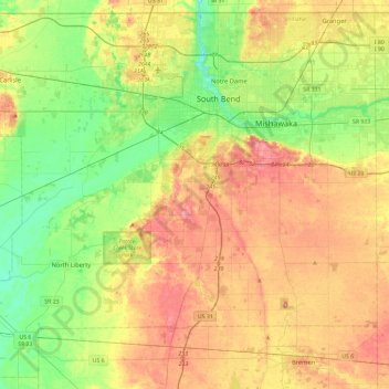
Name: Saint Joseph County topographic map, elevation, terrain.
Location: Saint Joseph County, Indiana, Estados Unidos (41.43286 -86.52664 41.76068 -86.05928)
Average elevation: 239 m
Minimum elevation: 201 m
Maximum elevation: 283 m
Other topographic maps
Click on a map to view its topography, its elevation and its terrain.
Chandler
Estados Unidos > Indiana > Chandler
Chandler, Pike County, Indiana, Estados Unidos
Average elevation: 151 m
Kosciusko County
Kosciusko County, Indiana, Estados Unidos
Average elevation: 262 m