
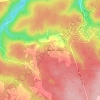
Brûly-De-Pesche topographic map
Interactive map
Click on the map to display elevation.
About this map
Name: Brûly-De-Pesche topographic map, elevation, terrain.
Average elevation: 320 m
Minimum elevation: 219 m
Maximum elevation: 375 m
Other topographic maps
Click on a map to view its topography, its elevation and its terrain.
Brûly
Belgique > Namur > Philippeville > Couvin
Les Sept Frères — probable déformation des Sept Frênes — au point culminant de la commune, à 375 m d’altitude, à moins d’un km de l’Ermitage, couvent des Récollets, aujourd’hui disparu.
Average elevation: 340 m