
Thank you for supporting this site ❤️
Make a donation
Make a donation
Culebras topographic map
Click on the map to display elevation.
Thank you for supporting this site ❤️
Make a donation
Make a donation
About this map
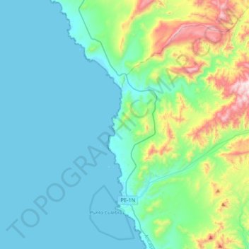
Name: Culebras topographic map, elevation, terrain.
Location: Culebras, Provincia de Huarmey, Áncash, Perú (-9.99472 -78.24495 -9.68911 -77.91550)
Average elevation: 486 m
Minimum elevation: 0 m
Maximum elevation: 2,087 m
Thank you for supporting this site ❤️
Make a donation
Make a donation
Other topographic maps
Click on a map to view its topography, its elevation and its terrain.