
Stuttgart-West topographic map
Interactive map
Click on the map to display elevation.
About this map
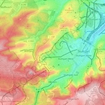
Name: Stuttgart-West topographic map, elevation, terrain.
Location: Stuttgart-West, Stuttgart, Baden-Württemberg, Deutschland (48.75524 9.07515 48.80012 9.17183)
Average elevation: 360 m
Minimum elevation: 231 m
Maximum elevation: 489 m
Other topographic maps
Click on a map to view its topography, its elevation and its terrain.
Vaihingen
Deutschland > Baden-Württemberg > Stuttgart
Vaihingen, Stuttgart, Regierungsbezirk Stuttgart, Baden-Württemberg, Deutschland
Average elevation: 456 m