
Inntal topographic map
Interactive map
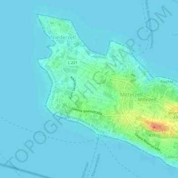
Click on the map to display elevation.
About this map
Name: Inntal topographic map, elevation, terrain.
Average elevation: 398 m
Minimum elevation: 392 m
Maximum elevation: 435 m
Other topographic maps
Click on a map to view its topography, its elevation and its terrain.
Reichenau
Deutschland > Baden-Württemberg > Landkreis Konstanz > Reichenau
Reichenau, Verwaltungsgemeinschaft Konstanz, Landkreis Konstanz, Baden-Württemberg, Deutschland
Average elevation: 397 m