
Thank you for supporting this site ❤️
Make a donation
Make a donation
Lancaster County topographic map
Click on the map to display elevation.
Thank you for supporting this site ❤️
Make a donation
Make a donation
About this map
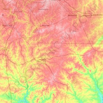
Name: Lancaster County topographic map, elevation, terrain.
Location: Lancaster County, South Carolina, United States (34.45818 -80.90955 35.07613 -80.41225)
Average elevation: 161 m
Minimum elevation: 64 m
Maximum elevation: 236 m
Thank you for supporting this site ❤️
Make a donation
Make a donation
Other topographic maps
Click on a map to view its topography, its elevation and its terrain.
Palmetto Dunes
United States > South Carolina > Beaufort County > Hilton Head Island
Average elevation: 3 m