
Thank you for supporting this site ❤️
Make a donation
Make a donation
Vikramam topographic map
Click on the map to display elevation.
Thank you for supporting this site ❤️
Make a donation
Make a donation
About this map
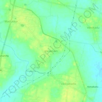
Name: Vikramam topographic map, elevation, terrain.
Location: Vikramam, Pattukkottai, Thanjavur, Tamil Nadu, 614903, India (10.44880 79.39153 10.48880 79.43153)
Average elevation: 16 m
Minimum elevation: 8 m
Maximum elevation: 25 m
Thank you for supporting this site ❤️
Make a donation
Make a donation
Other topographic maps
Click on a map to view its topography, its elevation and its terrain.
Manora Fort
India > Tamil Nadu > Pattukkottai > Sethubhavachatram > Villunivayal
Average elevation: 2 m