
Make a donation
Bandipur topographic map
Click on the map to display elevation.
Make a donation
Bandipur
Bandipur is located at 27.56 N, 84.25 E and an elevation of 1030m on a mountain saddle (Mahabharat range) approximately 700m above the Marsyangdi River Valley, 143 km to the west of Kathmandu and 80 km to the east of Pokhara. Since 1998 it is connected by an 8 km access road from Dumre (Prithvi Highway). Until then there was only an unreliable road, in monsoon usually not accessible or only by tractors. The mountain saddle, just 200m long, is barely wide enough to accommodate the main street lined by 2 –3 storey buildings on either side. At the backsides of these houses the mountainsides steeply descend and the gardens are only accessible by stairs.
Make a donation
About this map
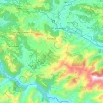
Name: Bandipur topographic map, elevation, terrain.
Location: Bandipur, Tanahun, Gandaki Province, 00000, Nepal (27.84264 84.34249 27.99457 84.45789)
Average elevation: 719 m
Minimum elevation: 233 m
Maximum elevation: 2,051 m
Make a donation
Other topographic maps
Click on a map to view its topography, its elevation and its terrain.
Bhimad
Nepal > Gandaki Province > Tanahun
Rangrung is famous for its altitude, accessing panoramic views of the broad Himalayan range. Hill Tower with telescope facilities will be constructed in the near future. This is popular for the resorts and overnight stayers. It has enormous potential for paragliding, this area is also famous for biodiversity.…
Average elevation: 544 m
Make a donation
Make a donation
Make a donation