
Bende topographic map
Interactive map
Click on the map to display elevation.
About this map
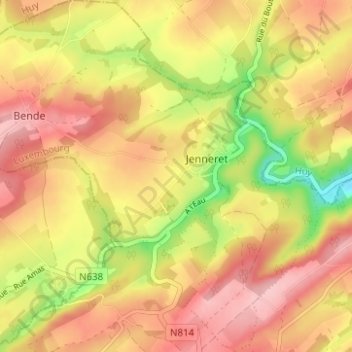
Name: Bende topographic map, elevation, terrain.
Location: Bende, Durbuy, Marche-en-Famenne, Luxembourg, Wallonia, Belgium (50.39101 5.40590 50.43061 5.46530)
Average elevation: 249 m
Minimum elevation: 155 m
Maximum elevation: 312 m
Other topographic maps
Click on a map to view its topography, its elevation and its terrain.
Durbuy
Belgium > Luxembourg > Marche-en-Famenne > Durbuy
Durbuy, Marche-en-Famenne, Luxembourg, Wallonia, 6940, Belgium
Average elevation: 222 m
Heyd
Belgium > Luxembourg > Marche-en-Famenne > Durbuy
Heyd, Durbuy, Marche-en-Famenne, Luxembourg, Wallonia, Belgium
Average elevation: 260 m