
Xiulin topographic map
Interactive map
Click on the map to display elevation.
About this map
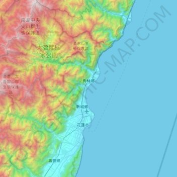
Name: Xiulin topographic map, elevation, terrain.
Location: Xiulin, Hualien County, Taiwan Province, 972, Taiwan (23.81880 121.25994 24.37053 121.77382)
Average elevation: 765 m
Minimum elevation: -3 m
Maximum elevation: 3,719 m
Because of its location beside the Central Mountain Range, the climate changes by altitude. Taroko National Park is located in Xiulin Township. In recent years, people in Xiulin have lobbied to change its name to "Taroko Township" (太魯閣鄉).
Other topographic maps
Click on a map to view its topography, its elevation and its terrain.
Taroko National Park
Taiwan > Taiwan Province > Hualien County
Taroko National Park, Hualien County, Taiwan Province, 972, Taiwan
Average elevation: 1,568 m
Hualien City
Taiwan > Taiwan Province > Hualien County
Hualien City, Hualien County, Taiwan Province, 970, Taiwan
Average elevation: 49 m
Gui'an
Taiwan > Taiwan Province > Hualien County > Fengbin > Gui'an
Gui'an, Jiqi Village, Fengbin, Hualien County, Taiwan Province, 977, Taiwan
Average elevation: 110 m