
Goldisthal topographic map
Interactive map
Click on the map to display elevation.
About this map
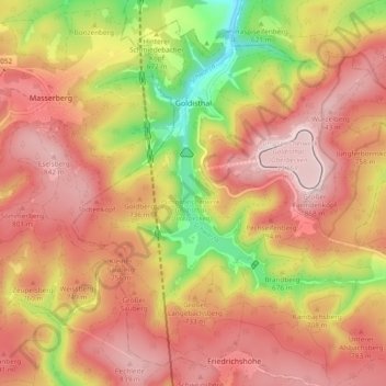
Name: Goldisthal topographic map, elevation, terrain.
Average elevation: 712 m
Minimum elevation: 472 m
Maximum elevation: 867 m
Other topographic maps
Click on a map to view its topography, its elevation and its terrain.
Sonneberg
Alemanha > Turíngia > Landkreis Sonneberg
Sonneberg, Landkreis Sonneberg, Turíngia, 96515, Alemanha
Average elevation: 586 m