
Colsterworth topographic map
Interactive map
Click on the map to display elevation.
About this map
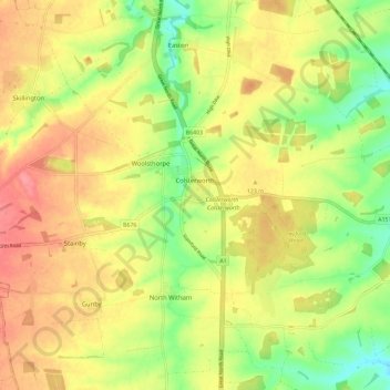
Name: Colsterworth topographic map, elevation, terrain.
Average elevation: 114 m
Minimum elevation: 72 m
Maximum elevation: 151 m
Other topographic maps
Click on a map to view its topography, its elevation and its terrain.
Old Somerby
United Kingdom > England > Lincolnshire > South Kesteven
Old Somerby, South Kesteven, Lincolnshire, England, NG33 4AH, United Kingdom
Average elevation: 115 m
Deeping St James
United Kingdom > England > Lincolnshire > South Kesteven
Deeping St James, South Kesteven, Lincolnshire, England, PE6 8EN, United Kingdom
Average elevation: 8 m
Langtoft
United Kingdom > England > Lincolnshire > South Kesteven
Langtoft, South Kesteven, Lincolnshire, England, PE6 9LR, United Kingdom
Average elevation: 8 m
Bourne
United Kingdom > England > Lincolnshire > South Kesteven
Bourne, South Kesteven, Lincolnshire, England, PE10 9EA, United Kingdom
Average elevation: 21 m
Market Deeping
United Kingdom > England > Lincolnshire > South Kesteven
Market Deeping, South Kesteven, Lincolnshire, England, PE6 8EA, United Kingdom
Average elevation: 8 m
Barkston
United Kingdom > England > Lincolnshire > South Kesteven
Barkston, South Kesteven, Lincolnshire, England, NG32 2NH, United Kingdom
Average elevation: 62 m