
Kayts topographic map
Interactive map
Click on the map to display elevation.
About this map
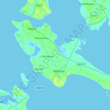
Name: Kayts topographic map, elevation, terrain.
Location: Kayts, Saravanai, Jaffna District, Northern Province, Sri Lanka (9.61235 79.84043 9.70347 79.98518)
Average elevation: 2 m
Minimum elevation: -2 m
Maximum elevation: 13 m
Velani is located at 9°24′N 79°32′E / 9.40°N 79.54°E / 9.40; 79.54. It is surrounded by the Palk Strait and at a distance of 6 kilometres (3.7 mi) south-west of Jaffna town. Though most of Velani district is a level plain and also has maximum elevation of 15 metres (49 ft) above mean sea level. The total area of this island is nearly 36 km2.