
Fushun City topographic map
Interactive map
Click on the map to display elevation.
About this map
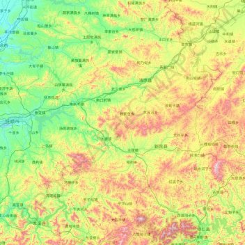
Name: Fushun City topographic map, elevation, terrain.
Location: Fushun City, Liaoning, 113000, China (41.23690 123.65804 42.47662 125.48427)
Average elevation: 414 m
Minimum elevation: 57 m
Maximum elevation: 1,314 m
Other topographic maps
Click on a map to view its topography, its elevation and its terrain.
Fengshan
China > Liaoning > Fengcheng City
Fengshan, Fengcheng City, Dandong City, Liaoning, China
Average elevation: 156 m