
Malham topographic map
Interactive map
Click on the map to display elevation.
About this map
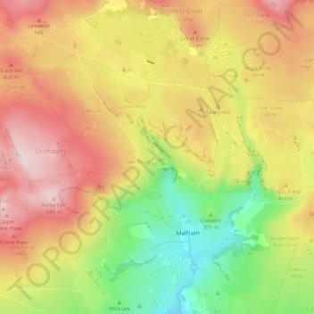
Name: Malham topographic map, elevation, terrain.
Location: Malham, North Yorkshire, England, United Kingdom (54.05408 -2.20986 54.09540 -2.11451)
Average elevation: 371 m
Minimum elevation: 178 m
Maximum elevation: 552 m
Other topographic maps
Click on a map to view its topography, its elevation and its terrain.
Cow Hill
United Kingdom > England > North Yorkshire > Halton West
Cow Hill, Halton West, North Yorkshire, England, BD23 4LP, United Kingdom
Average elevation: 145 m
Settle
United Kingdom > England > North Yorkshire
Settle, North Yorkshire, England, United Kingdom
Average elevation: 238 m
Middleham
United Kingdom > England > North Yorkshire
Middleham, North Yorkshire, England, United Kingdom
Average elevation: 157 m
Scarborough
United Kingdom > England > North Yorkshire > Scarborough
Scarborough, North Yorkshire, Yorkshire and the Humber, England, United Kingdom
Average elevation: 50 m