
Puerto Galera topographic map
Interactive map
Click on the map to display elevation.
About this map
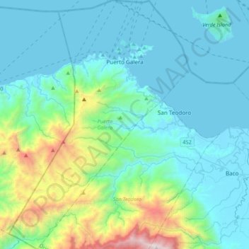
Name: Puerto Galera topographic map, elevation, terrain.
Location: Puerto Galera, Oriental Mindoro, Mimaropa, 5221, Philippines (13.26026 120.80067 13.58084 121.03968)
Average elevation: 409 m
Minimum elevation: 0 m
Maximum elevation: 2,553 m
Other topographic maps
Click on a map to view its topography, its elevation and its terrain.
Malamig
Philippines > Oriental Mindoro > Calapan
Malamig, Calapan, Oriental Mindoro, Mimaropa, Philippines
Average elevation: 9 m