
Bassi topographic map
Interactive map
Click on the map to display elevation.
About this map
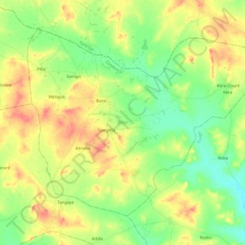
Name: Bassi topographic map, elevation, terrain.
Location: Bassi, Zondoma, North, Burkina Faso (13.23424 -2.30530 13.38191 -2.10682)
Average elevation: 330 m
Minimum elevation: 304 m
Maximum elevation: 364 m
Other topographic maps
Click on a map to view its topography, its elevation and its terrain.
Bobo-Dioulasso
Bobo-Dioulasso, Houet, Upper-Basins, 00000, Burkina Faso
Average elevation: 388 m
Komoé River
Komoé River, Wolokonto, Léraba, Waterfalls, Burkina Faso
Average elevation: 456 m