
Agency Lake topographic map
Interactive map
Click on the map to display elevation.
About this map
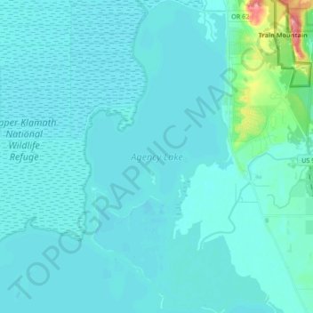
Name: Agency Lake topographic map, elevation, terrain.
Location: Agency Lake, Klamath County, Oregon, United States (42.46225 -122.00649 42.58588 -121.90765)
Average elevation: 1,266 m
Minimum elevation: 1,256 m
Maximum elevation: 1,378 m
Other topographic maps
Click on a map to view its topography, its elevation and its terrain.
Chiloquin
United States > Oregon > Klamath County
Chiloquin, Klamath County, Oregon, United States
Average elevation: 1,302 m