
Shah Alam topographic map
Interactive map
Click on the map to display elevation.
About this map
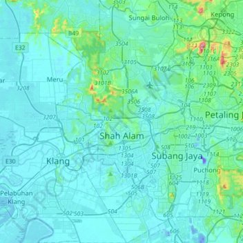
Name: Shah Alam topographic map, elevation, terrain.
Location: Shah Alam, Petaling, Selangor, Malaysia (2.94998 101.42773 3.22995 101.59229)
Average elevation: 28 m
Minimum elevation: -46 m
Maximum elevation: 323 m
Located in Klang Valley, Shah Alam topography is mostly flat, except in the northern part of the city where it features a prominent rolling hill.