
Beylagan District topographic map
Interactive map
Click on the map to display elevation.
About this map
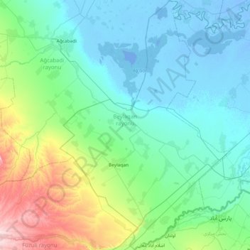
Name: Beylagan District topographic map, elevation, terrain.
Location: Beylagan District, Mil-Mughan, 1200, Azerbaijan (39.57202 47.44025 40.14155 47.94868)
Average elevation: 58 m
Minimum elevation: -11 m
Maximum elevation: 338 m
Beylagan is one of the southwestern districts of Azerbaijan and situated in the Mil valley of the Kur – Araz lowland and in the middle of the Kur and Araz rivers. Geographical coordinates are 39°45’ North latitude and 47°30’ West longitude and bordering Agchabadi, Zardab, Imishli, Fuzuli districts and Iran Islamic Republic in the south-east. Some parts of the Harami plain belong to the district and the northeast part is below the ocean level. More than 40% of the territory is 0 – 100 meters, 25% is 100 – 200 meters and 35% is below 0 meters. Absolute altitude changes between 200 – 250 meters towards Harami plain. Generally, Beylagan is considered a seismic active zone.
Other topographic maps
Click on a map to view its topography, its elevation and its terrain.
Saatly District
Saatly District, Mil-Mughan, 4900, Azerbaijan
Average elevation: -12 m
Imishli District
Imishli District, Mil-Mughan, 3000, Azerbaijan
Average elevation: 5 m
Sabirabad District
Sabirabad District, Mil-Mughan, Azerbaijan
Average elevation: 0 m