
Vaikom topographic map
Interactive map
Click on the map to display elevation.
About this map
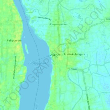
Name: Vaikom topographic map, elevation, terrain.
Location: Vaikom, Kottayam, Kerala, 686141, India (9.70978 76.35260 9.78978 76.43260)
Average elevation: 4 m
Minimum elevation: -1 m
Maximum elevation: 13 m
Other topographic maps
Click on a map to view its topography, its elevation and its terrain.
Arakkulam
India > Kerala > Vaikom > Thalayolaparambu > Chundangakari vadachira colony
Average elevation: 6 m