
Saas-Grund topographic map
Interactive map
Click on the map to display elevation.
About this map
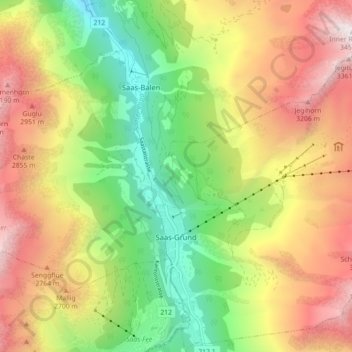
Name: Saas-Grund topographic map, elevation, terrain.
Location: Saas-Grund, Visp, Wallis, 3910, Switzerland (46.10775 7.93139 46.16922 8.01236)
Average elevation: 2,317 m
Minimum elevation: 1,353 m
Maximum elevation: 3,438 m
Other topographic maps
Click on a map to view its topography, its elevation and its terrain.
Monte Rosa
Switzerland > Wallis > Visp > Zermatt
The peak is distinguished by the name Dufourspitze (in German, lit. Dufour Peak; French: Pointe Dufour, Italian: Punta Dufour). This replaced the former name Höchste Spitze (English: Highest Peak) that was indicated on the Swiss maps before the Federal Council, on January 28, 1863, decided to rename the…
Average elevation: 4,033 m