
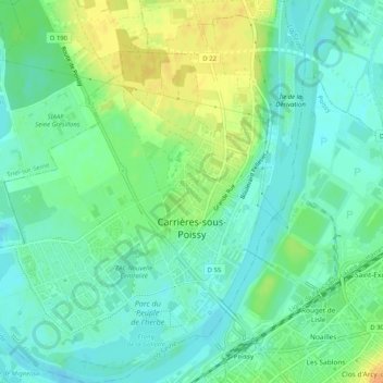
Carrières-sous-Poissy topographic map
Interactive map
Click on the map to display elevation.
About this map
Name: Carrières-sous-Poissy topographic map, elevation, terrain.
Average elevation: 29 m
Minimum elevation: 17 m
Maximum elevation: 49 m
Other topographic maps
Click on a map to view its topography, its elevation and its terrain.
Villennes-sur-Seine
France > Ile-de-France > Yvelines > Villennes-sur-Seine
Villennes-sur-Seine, Saint-Germain-en-Laye, Yvelines, Ile-de-France, Metropolitan France, 78670, France
Average elevation: 64 m
Versailles
France > Ile-de-France > Yvelines
Versailles, Yvelines, Ile-de-France, Metropolitan France, 78000, France
Average elevation: 142 m
Poissy
France > Ile-de-France > Yvelines > Poissy
Poissy, Saint-Germain-en-Laye, Yvelines, Ile-de-France, Metropolitan France, 78300, France
Average elevation: 67 m