
Chikkamagaluru topographic map
Interactive map
Click on the map to display elevation.
Chikkamagaluru
Chikmagalur is situated in the Malenadu region of Karnataka in the Deccan plateau in the foothills of the Western Ghats. It is situated at an elevation of 1,090 metres (3,580 ft) above mean sea level, meaning, it is the third highest city in Karnataka. The Yagachi River has its source near the town and flows in the south-easterly direction before uniting with the Hemavati river.
About this map
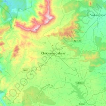
Name: Chikkamagaluru topographic map, elevation, terrain.
Average elevation: 1,052 m
Minimum elevation: 713 m
Maximum elevation: 1,883 m