
Candelária topographic map
Interactive map
Click on the map to display elevation.
About this map
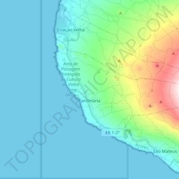
Name: Candelária topographic map, elevation, terrain.
Location: Candelária, Madalena, Azores, Portugal (38.44058 -28.54184 38.50330 -28.40031)
Average elevation: 155 m
Minimum elevation: 0 m
Maximum elevation: 963 m
Other topographic maps
Click on a map to view its topography, its elevation and its terrain.
Mount Pico
Mount Pico (Portuguese: Montanha do Pico) is a currently dormant stratovolcano located on Pico Island, in the mid-Atlantic archipelago of the Azores. It is the highest mountain in Portugal, at 2,351 metres (7,713 ft) above sea level, and is one of the highest Atlantic mountains; it is more than twice the…
Average elevation: 1,694 m