
Chacaltaya topographic map
Interactive map
Click on the map to display elevation.
About this map
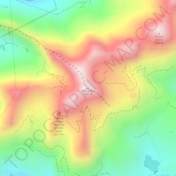
Name: Chacaltaya topographic map, elevation, terrain.
Location: Chacaltaya, La Paz, Pedro Domingo Murillo, La Paz, Bolivia (-16.34958 -68.12706 -16.34948 -68.12696)
Average elevation: 5,068 m
Minimum elevation: 4,758 m
Maximum elevation: 5,363 m
Chacaltaya (Mollo language for "bridge of winds" or "winds meeting point", Aymara for "cold road") is a mountain in the Cordillera Real, one of the mountain ranges of the Cordillera Oriental, itself a range of the Bolivian Andes. Its elevation is 5,421 meters (17,785 ft). Chacaltaya's glacier — which was as old as 18,000 years — had an area of 0.22 km2 (0.085 sq mi) in 1940, which had been reduced to 0.01 km2 (0.0039 sq mi) in 2007 and was completely gone by 2009. Half of the meltdown, as measured by volume, took place before 1980. The final meltdown after 1980, due to missing precipitation and the warm phase of El Niño, resulted in the glacier's disappearance in 2009. The glacier was located about 30 kilometers (19 mi) from La Paz, near Huayna Potosí mountain.