
Make a donation
Kurunegala topographic map
Click on the map to display elevation.
Make a donation
Kurunegala
Located at an altitude of 116 metres (381 ft) above sea level, Kurunegala is surrounded by coconut plantations and rubber estates. There are eight very noticeable large rocks that encircle and dominate the city. Kurunegala's rocks rise from the plain below and have characteristic names, six of which come from the animals that they are imagined to represent. The largest among them is Ethagala or the "Elephant Rock" (though the translation is actually tusker), reaches 325 metres (1,066 ft). The shape of Ethagala resembles an elephant.
Make a donation
About this map
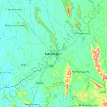
Name: Kurunegala topographic map, elevation, terrain.
Average elevation: 146 m
Minimum elevation: 46 m
Maximum elevation: 796 m
Make a donation
Other topographic maps
Click on a map to view its topography, its elevation and its terrain.
Beautiful strange rock formations
Sri Lanka > North Western Province > Kudiramale
Average elevation: 4 m
Make a donation
Wembu Wewa
Sri Lanka > North Western Province > Ihala Puliyankulama > Weheragala
Average elevation: 55 m
Make a donation